History of the Colonization of America and the original 13 Colonies Maps of Colonial America: The Establishment and Settlement of the 13 original colonies
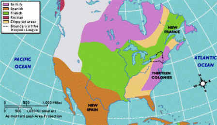
Map of Colonial America 1754
The Map of Colonial America in 1754 provides a bird's-eye view of its size in relation the North America and the lands claimed by the different countries of Europe. ● British
● French
● Spanish
● Russian
● Disputed Lands |
| |
Map of Colonial America in 1754 |
Maps of Colonial America - New England
The Map of early Colonial America highlights the location of the lost colony on Roanoke Island and the Jamestown Colony. 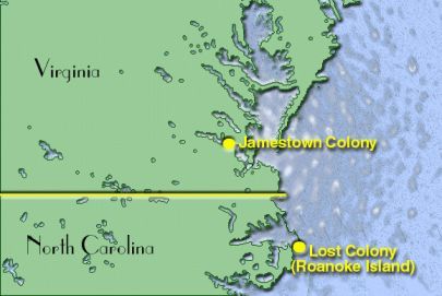
Map of Jamestown Colony, Virginia Maps of Colonial America - New England
The Map highlights the region of New England. The four New England Colonies of Colonial America included the colonies of New Hampshire, Massachusetts Bay Colony, Rhode Island and Connecticut. 
Map of the New England Maps of Colonial America - Middle Colonies
The Middle Colonies shown on this Map of Colonial America composed of Pennsylvania, Delaware, New York, and New Jersey. 
Map of the Middle Colonies Maps of Colonial America - Southern Colonies
This Map provides a closer view of the Southern Colonies. The five Southern Colonies of Colonial America composed of Maryland, Virginia, North Carolina, South Carolina and Georgia. 
Map of the Southern Colonies
Maps of Colonial America - Proclamation of 1763 - Proclamation Line Map
This Map of Colonial America shows the Proclamation Line Map of 1763. The Royal Proclamation of 1763 was an attempt by Great Britain to separate the white settlements of the colonies from Indian territories. The Proclamation of 1763 resulted in a massive border, or Boundary Line which is shown on the Proclamation Line Map. The colonists perceived that the Proclamation of 1763 demonstrated that the British King was on the side of the Indians to the detriment of the colonists.

Maps of Colonial AmericaInteresting Facts and information via the Maps of Colonial America Maps of Colonial America Map of Colonial America 13 Colonies The Map of New England, the Middle and Southern colonies Social Studies Homework help for kids with Maps of Colonial America
| 